Enhance Learning with
Immersive 3D Maps

Revolutionize Your Educational Experience! Our interactive 3D maps provide a dynamic platform for enhancing learning. Whether you’re a school, university, or educational program, explore how 3D maps can elevate your curriculum.

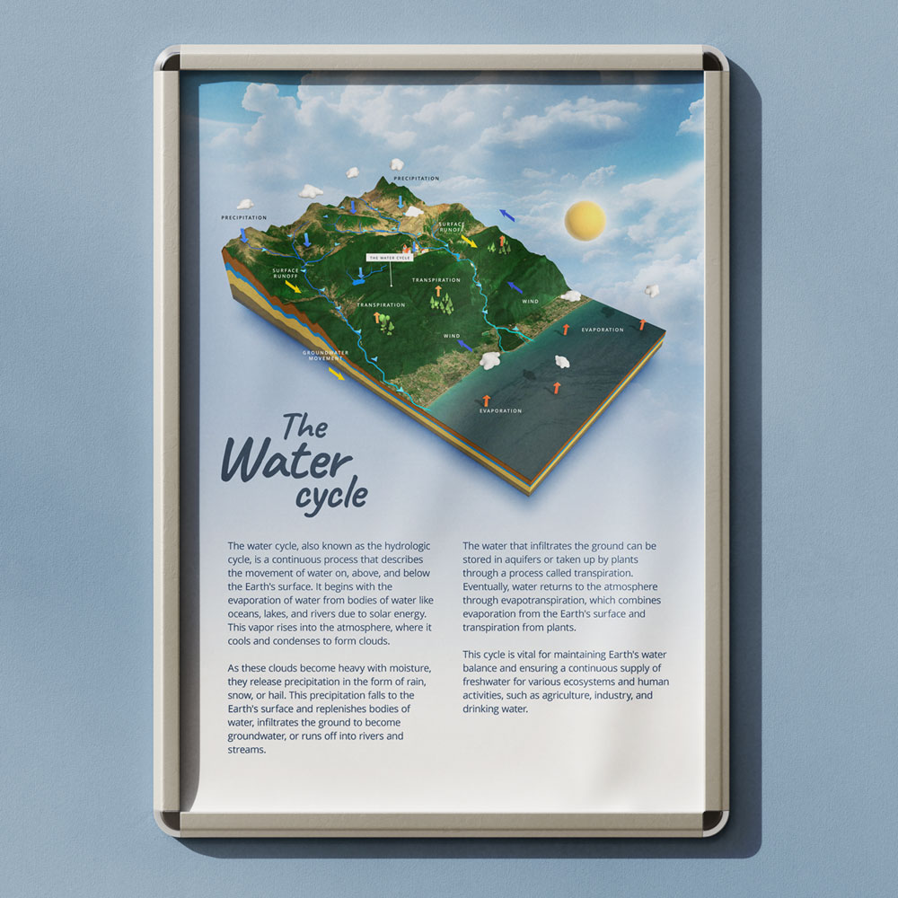
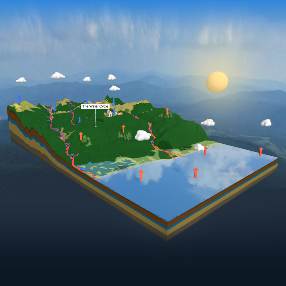
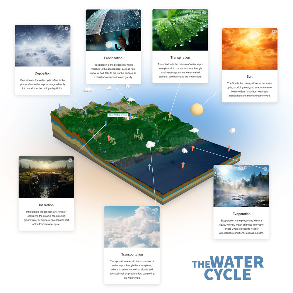
The Water Cycle 3D Map

The example 3D map “Water Cycle” illustrates how educators can creatively visualize learning materials using a 3D map. Your students can rotate the 3D map and discover hidden content by clicking on the icons. Technical note: The original texture of this 3D map was edited using an image editor, and a transparent image was overlaid onto the actual texture depicting the rivers using the Image Overlay feature.

Now, give it a try yourself: rotate the 3D map, tilt it, zoom in and then click on the 3D pins on the map to learn more!

Enhancing Travel Experiences with Interactive 3D Maps

Welcome to a new dimension of travel planning and exploration! Dive into the innovative world of interactive 3D maps and discover how they can transform the way you present travel experiences to your clients as a forward-thinking travel agency.

Now, give it a try yourself: rotate the 3D map, tilt it, and then click on the 3D pins on the map to learn more about each stop of the journey!

Infiltration
Infiltration is the process where water soaks into the ground, replenishing groundwater or aquifers, an essential part of the Earth's water cycle.
Sun
The Sun is the primary driver of the water cycle, providing energy to evaporate water from the Earth's surface, leading to precipitation and maintaining the cycle.
Precipitation
Precipitation is the process by which moisture in the atmosphere, such as rain, snow, or hail, falls to the Earth's surface as a result of condensation and gravity.
Precipitation
Precipitation is the process by which moisture in the atmosphere, such as rain, snow, or hail, falls to the Earth's surface as a result of condensation and gravity.
Transpiration
Transpiration is the release of water vapor from plants into the atmosphere through small openings in their leaves called stomata, contributing to the water cycle.
Transpiration
Transpiration is the release of water vapor from plants into the atmosphere through small openings in their leaves called stomata, contributing to the water cycle.
Transpiration
Transpiration is the release of water vapor from plants into the atmosphere through small openings in their leaves called stomata, contributing to the water cycle.
Transportation
Transportation refers to the movement of water vapor through the atmosphere, where it can condense into clouds and eventually fall as precipitation, completing the water cycle.
Condensation
Condensation occurs when water vapor in the air cools and transforms into liquid water, forming clouds, an integral part of the water cycle.
Evaporation
Evaporation is the process by which a liquid, typically water, changes into vapor or gas when exposed to heat or atmospheric conditions, such as sunlight.
Precipitation
Precipitation is the process by which moisture in the atmosphere, such as rain, snow, or hail, falls to the Earth's surface as a result of condensation and gravity.
Deposition
Deposition in the water cycle refers to the phase when water vapor changes directly into ice without becoming a liquid first.
Evaporation
Evaporation is the process by which a liquid, typically water, changes into vapor or gas when exposed to heat or atmospheric conditions, such as sunlight.
Evaporation
Evaporation is the process by which a liquid, typically water, changes into vapor or gas when exposed to heat or atmospheric conditions, such as sunlight.
Evaporation
Evaporation is the process by which a liquid, typically water, changes into vapor or gas when exposed to heat or atmospheric conditions, such as sunlight.
Deposition
Deposition in the water cycle refers to the phase when water vapor changes directly into ice without becoming a liquid first.

Expanding Horizons Through Virtual Exploration: 3D Maps in Education

Unlocking Boundless Learning Opportunities: Educational institutions can harness the power of 3D maps to take students on captivating virtual journeys to explore various places and ecosystems. Whether it’s a visit to the Amazon Rainforest, a historic world city, or an in-depth exploration of geological formations, 3D maps offer an immersive and educational experience.

Through these virtual excursions, students can navigate through detailed 3D representations of real-world locations. They can delve into geographical features, historical landmarks, and ecological systems as if they were physically present. This hands-on learning approach fosters a deeper comprehension of subjects such as geography, history, and science.

Educators can integrate 3D maps seamlessly into their curricula, making lessons more engaging and interactive. Students can interact with maps, discover hidden details, and gain insights that go beyond textbooks. It’s a transformative way to educate, offering students a global perspective from the comfort of their classrooms. With 3D maps, educational institutions can bring the world closer to students, making learning not only informative but also exhilarating.

Unleash Your Teaching Creativity with 3D Maps

Elevate your educational resources with customizable handouts featuring high-resolution 3D maps. Craft dynamic learning materials that captivate and engage your students. With the ability to rotate maps to any position and perspective and download them with a transparent background, you have the power to create truly immersive and interactive teaching aids. Make complex subjects come to life in your classroom like never before.

Bring Geography to Life with 3D Printing

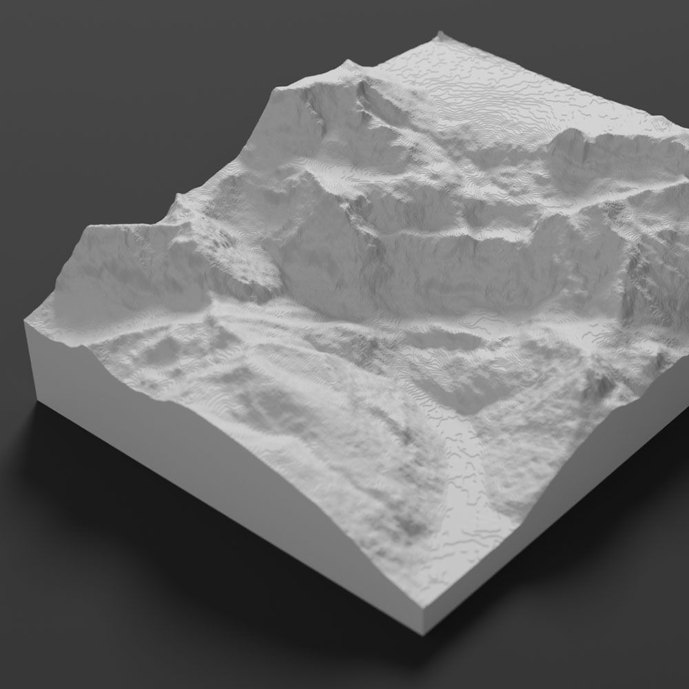
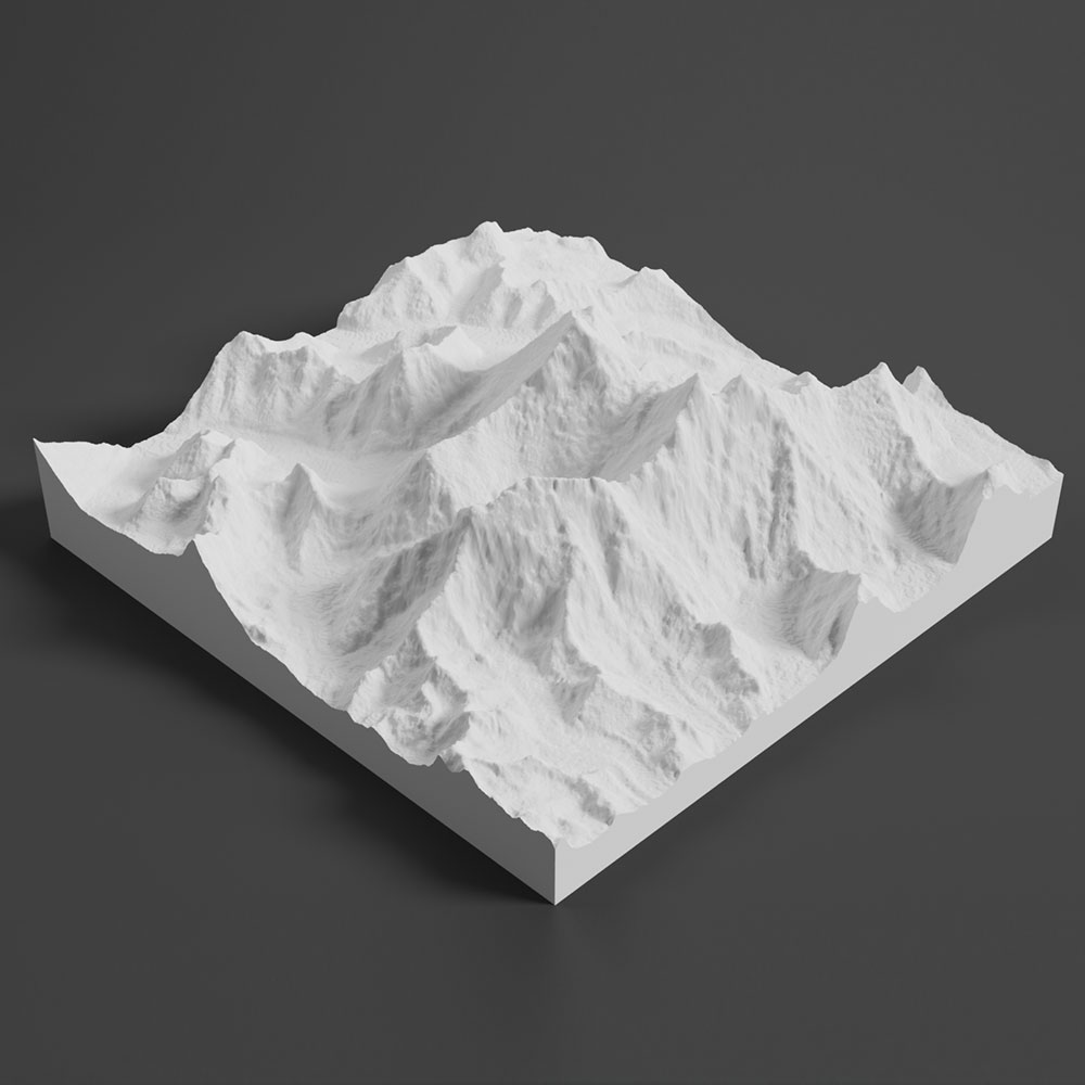
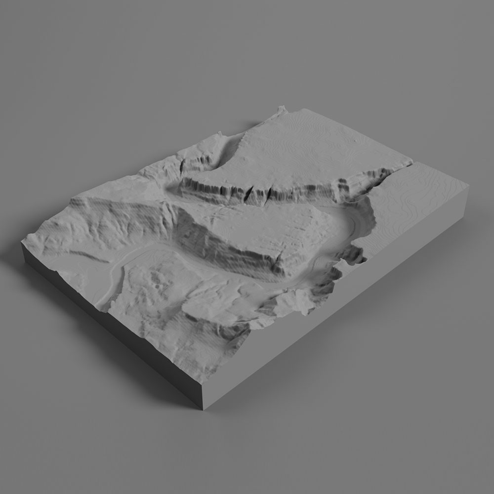
Revolutionize your teaching materials by 3D printing our intricate 3D maps. As a teacher, you can now harness the power of tactile learning, allowing students to physically explore geographical features. Export our 3D maps as printable files and immerse your class in a hands-on educational experience. From mountain ranges to river valleys, let your students touch and feel the world’s landscapes, making geography an unforgettable journey.